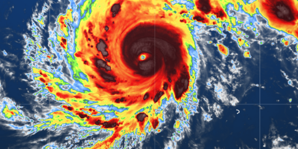
- Super Typhoon Dolphin continues to strengthen as it slowly tracks northwest across the Western Pacific toward Asia, as a powerful Category 5-equivalent storm with sustained winds of 160 mph.
- The storm intensified dramatically, jumping by 95 mph in a 24-hour period to reach 145 mph by Tuesday afternoon, and is expected to peak at 160 to 170 mph.
- Dolphin peaked with maximum sustained winds of 165 mph (270 km/h) on Thursday morning local time, with a 910 mb central pressure, after an explosive intensification cycle that lasted less than 36 hours.
- Super Typhoon Dolphin poses no immediate threat to land, at least through the weekend, but it is a storm worth watching because it is both historic – in fact, Dolphin is the strongest typhoon on record to develop so close to the International Date Line – and entirely consistent with the onset of a strong El Niño event.
- The forecast from the Joint Typhoon Warning Center (JTWC) calls for Super Typhoon Dolphin to maintain its current intensity through at least the weekend.
- Dolphin is the planet’s fifth Category 5 tropical cyclone of 2026.
Super Typhoon Dolphin has rapidly intensified to a Category 5 storm, boasting sustained winds of 160 mph and a pinhole eye measuring 6 to 7 miles wide. The storm's intensity surged by 95 mph within 24 hours, reaching 165 mph on Thursday morning local time, with a 910 mb central pressure.12346
According to the Joint Typhoon Warning Center, Dolphin is the fifth Category 5 tropical cyclone of 2026 and is expected to maintain its intensity through the weekend. While it poses no immediate threat to land, it is significant as the strongest typhoon recorded near the International Date Line, aligning with the onset of a strong El Niño event.5

The storm's explosive growth is notable, having intensified dramatically in less than 36 hours. Experts are closely monitoring its path as it continues to track northwest across the Western Pacific toward Asia.
“Dolphin is the strongest typhoon on record to develop so close to the International Date Line, with maximum sustained winds peaking at 165 mph after an explosive intensification cycle. The Joint Typhoon Warning Center forecasts the storm to maintain its intensity through at least the weekend, posing no immediate threat to land.”
 FOX Weather
 Yale Climate Connections



