- The system, which got better organized Wednesday overnight into Thursday morning according to the NHC, may form a short-lived tropical depression or storm on Thursday before facing hostile conditions starting Friday.
- The system will encounter dry air and wind shear as it approaches the Leeward Islands, both enhanced by the strengthening El Niño, which are hostile to tropical systems.
- Some computer models suggest the system could develop or redevelop later next week near the Bahamas or Bermuda Triangle, when the atmosphere may become more favorable.
- The Atlantic season is nearing its typical peak around the second week of September, but has been quiet with only three short-lived tropical storms and no hurricanes, largely due to El Niño enhancing wind shear and dry air.
- A tropical depression or potentially Tropical Storm Dolly could briefly form in the eastern Atlantic Ocean despite an increasingly hostile environment enhanced by El Niño.
- If the system develops with maximum sustained winds of at least 39 mph (63 km/h), it would be named Tropical Storm Dolly.
- Even if the system develops, it is likely to weaken as it nears the Leeward Islands this weekend; if it never develops, the disturbance will continue moving west-northwest.
- Even if no development occurs, tropical waves can bring gusty winds and heavy rain, so the Lesser Antilles and Puerto Rico can still see impacts.
- It is too soon to know if development will happen, and if it does, its track and strength; it's a reminder to have a hurricane plan ready and monitor forecasts, as one storm can make a season impactful.
Forecasters are monitoring a weather system off Africa that may develop into Tropical Storm Dolly. The National Hurricane Center (NHC) reported that conditions are somewhat favorable for the area of thunderstorms south of the Cabo Verde Islands to become a tropical depression this week.1011
If it develops, with maximum sustained winds of at least 39 mph (63 km/h), it will be named Tropical Storm Dolly. However, the NHC has forecast a below-average Atlantic hurricane season due to El Niño, predicting eight to 14 named storms, with three to six reaching hurricane strength.34789
Despite the potential for a brief formation, the system will encounter hostile conditions such as dry air and wind shear as it approaches the Leeward Islands, likely leading to its weakening.1213
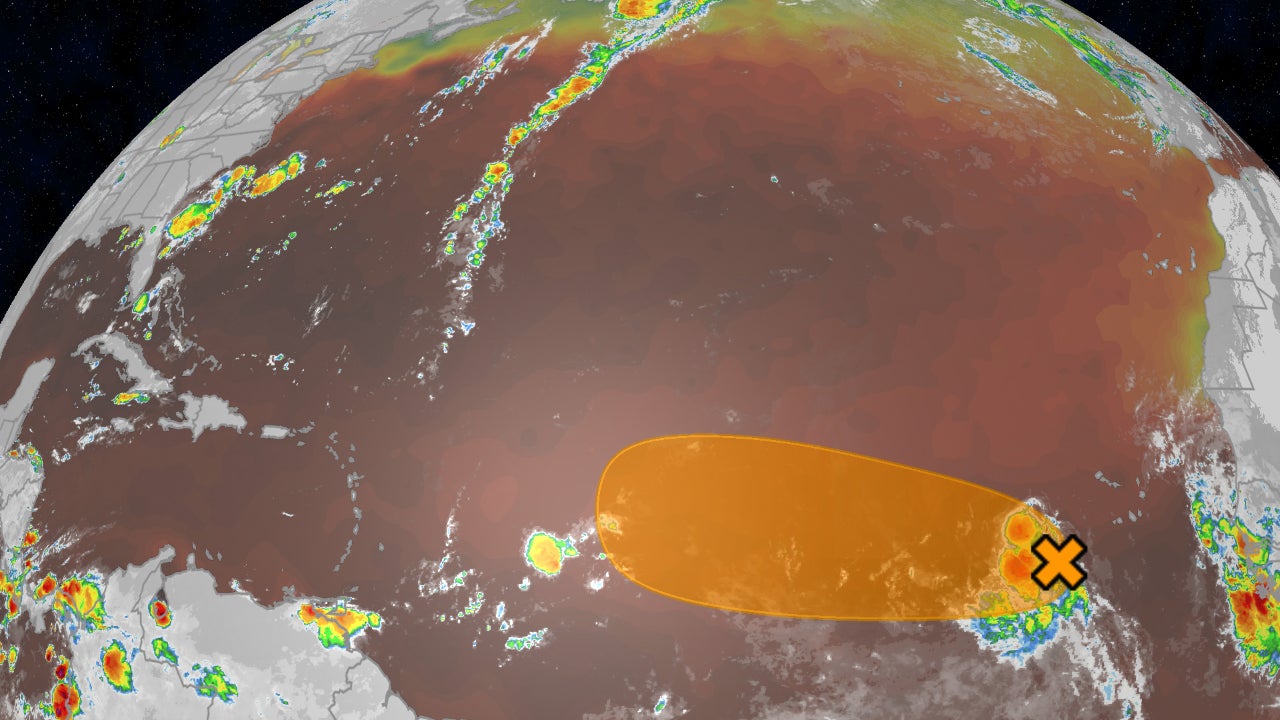
The NHC noted that even if the system does not develop, it will continue moving west-northwest, potentially impacting the Lesser Antilles and Puerto Rico with gusty winds and heavy rain.14
As the Atlantic hurricane season nears its peak in mid-September, only three short-lived tropical storms have formed so far, attributed to the El Niño conditions enhancing wind shear and creating a dry atmosphere.
It serves as a reminder that one storm can significantly impact the hurricane season, and residents should remain vigilant and prepared.151617
“The system could develop into a short-lived depression or storm Thursday before facing dry air and wind shear near the Leeward Islands this weekend. NOAA forecasts a below-average season with 8-14 named storms, but only three short-lived storms have formed so far.”
 CP24
CP24 The Weather Channel






